

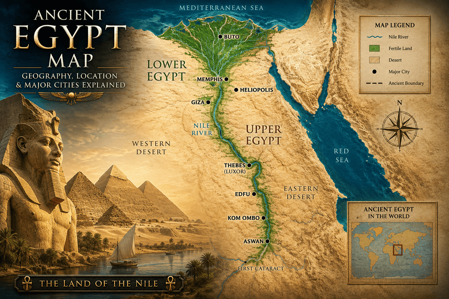
Discover where ancient Egypt was located on a map. Explore Upper Egypt, Lower Egypt, the Nile River, and major cities that shaped one of history’s greatest civilizations. The annual flood also drove the tax assessments described in our article on the ancient Egypt census.
Introduction
Close your eyes and imagine you’re standing in Cairo, looking at a historical map of ancient Egypt. You see this narrow strip of green—the Nile Valley—cutting through an ocean of desert. That river, and the land immediately surrounding it, was essentially everything that mattered for ancient Egyptian civilization.
When we talk about ancient Egypt on a map, we’re not talking about the Egypt you see today. Modern Egypt is much larger. Ancient Egypt was concentrated, intense, focused on one thing: the Nile River and the fertile land it created.
Understanding where ancient Egypt actually was—geographically, spatially, in relation to other regions—is the foundation for understanding everything else about this civilization. How they lived, why they built where they did, why the Nile was so crucial, how they defended themselves, what they traded with neighbors—it all comes down to geography.
So let me walk you through this. Let me show you what ancient Egypt actually looked like on a map, where the major cities were, why the geography mattered so much, and how this narrow ribbon of civilization produced one of history’s most remarkable societies.
Ancient Egypt Map: The Nile River and Geography
Here’s the fundamental truth about ancient Egypt: it existed because of the Nile River. Not metaphorically. Literally.
The Nile is the world’s longest river—over 4,000 miles, flowing from central Africa northward through Sudan and Egypt into the Mediterranean Sea. For most of its length, the Nile flows through desert. But in Egypt, the Nile created something extraordinary: a fertile floodplain.
Every year—and this was absolutely crucial to Egyptian survival—the Nile flooded. From June through September, rains in central Africa brought massive amounts of water downriver. The water would overflow its banks, flooding the surrounding land with water and nutrient-rich silt from upstream. When the floods receded, they left behind incredibly fertile black soil.
This is why ancient Egyptians called their land “Kemet”—the black land. Not because of skin tone or anything like that. They called it the black land because of the black soil left by the Nile’s annual floods.
On a map, if you look at the Nile Valley, you can see exactly why this mattered. The river creates this green corridor through an otherwise utterly barren desert. Step a few miles away from the Nile, and you’re in sand dunes with virtually no water or vegetation. But immediately adjacent to the Nile? Lush, fertile, abundant.
The ancient Egyptians built their entire civilization in that fertile strip. They didn’t really settle the desert. They settled the Nile Valley, the Nile Delta, and the areas within maybe 15-20 miles of the river. Everything else was “Deshret”—the red land—desert territory, inhospitable, mostly avoided except for mining and quarrying.
Upper Egypt vs Lower Egypt: Confusing Geography That Makes Sense When You Know the Nile
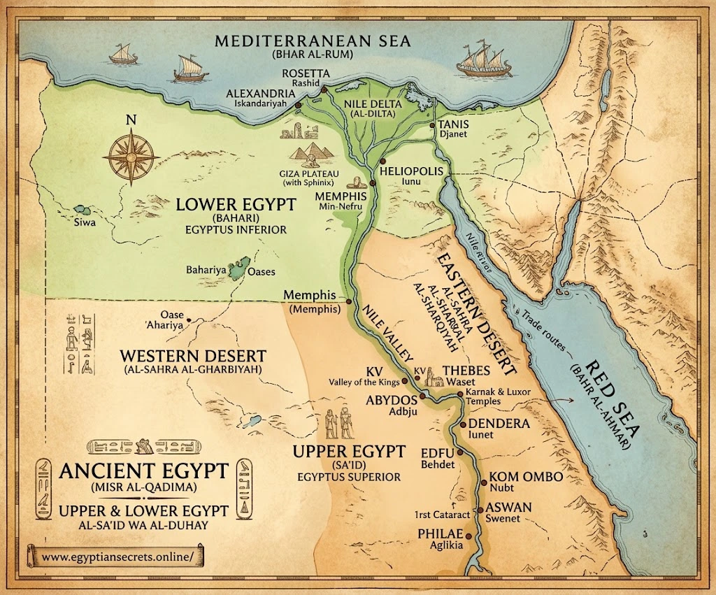
Here’s something that confuses people looking at ancient Egypt on a map: Upper Egypt and Lower Egypt.
You’d think “Upper” meant farther north and “Lower” meant farther south, right? But it’s the opposite. And the reason is the Nile.
Upper Egypt is southern Egypt. It’s called “upper” because it’s upriver—higher in elevation along the Nile’s course. Upper Egypt stretches from roughly the first cataract (waterfall/rapids) of the Nile near Aswan southward.
Lower Egypt is northern Egypt. It’s called “lower” because it’s downriver—where the Nile flows to lower elevations as it approaches the Mediterranean. Lower Egypt includes the Nile Delta—that triangular region where the Nile splits into multiple branches before entering the Mediterranean.
On a map, you see Upper Egypt as the long, narrow stretch along the Nile, roughly following the river’s path as it flows north. You see Lower Egypt as the triangle-shaped Nile Delta at the northern end, where the river branches and spreads out before reaching the sea.
This distinction was incredibly important in ancient Egypt. Upper Egypt and Lower Egypt had different characteristics, different regional identities, different traditions. Ancient Egyptian history was often about these two regions unifying or competing. Major cities would rise in one region or the other. Dynasties would come from different regions.
On a map, you can literally see why this mattered—they were geographically and ecologically distinct regions.
Major Cities on an Ancient Egypt Map
Let’s talk about where the actual cities were. Because on an ancient Egypt map, the cities cluster in very specific places—all along the Nile, because that’s where water was.
Memphis (located roughly where modern Cairo is) was the capital of Old Kingdom Egypt and remained incredibly important throughout history. It’s situated in the transition zone between Upper and Lower Egypt, giving it strategic importance. On a map, you see Memphis positioned right where the Nile Valley starts to widen into the Delta.
Thebes (modern Luxor) was the great capital of the New Kingdom. Thebes is deep in Upper Egypt, in the south. On a map, it’s far upriver from Memphis, showing the shift in Egypt’s power center during later periods. The Temple of Karnak and Valley of the Kings are near Thebes—some of Egypt’s most iconic sites.
Alexandria (founded by Alexander the Great, so technically not ancient Egypt proper) was founded at the Mediterranean coast and became hugely important. On a map, it’s on the northern coast, at the northwestern tip of the Nile Delta.
Giza is where the Great Pyramids are built, positioned just south of modern Cairo, on the Nile near Memphis. On a historical map, you see it as part of Memphis’s sphere of influence. See our article on how the pyramids were built for what stood there.
Heliopolis was an ancient religious center near Memphis, home to the temple of Ra. It’s positioned in Lower Egypt, in the Delta region.
Abydos was a major religious site in Upper Egypt, associated with the god Osiris. On a map, it’s positioned in south-central Egypt.
Aswan is at Egypt’s southern border, where the Nile’s cataracts (rapids) made further river travel difficult. On a map, Aswan marks the southern boundary of Egypt proper. It was important as a trading post and defensive position.
When you look at all these cities on a map, what you notice is they’re all positioned strategically along the Nile. There are no ancient Egyptian cities in the desert interior. It’s all river valley, all delta. Geography determined everything about where people could live.
The Nile Delta: Lower Egypt’s Unique Geography
The Nile Delta deserves special attention on any ancient Egypt map, because it’s geographically unique.
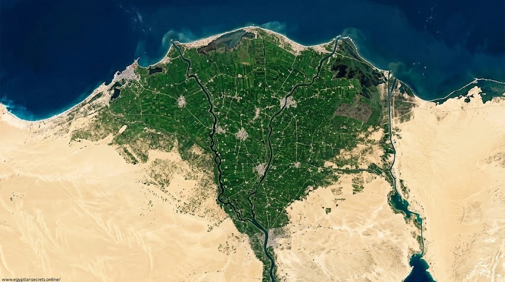
As the Nile approaches the Mediterranean, it slows down and spreads out. The river branches into multiple channels, creating this distinctive triangular shape that looks like a fan or delta (which is where the Greek letter delta gets its name—the shape).
The Delta is incredibly fertile—even more so than Upper Egypt. It’s close to the Mediterranean, so it has more access to sea trade. On a map, you see it as this broader, richer region compared to the long narrow strip of Upper Egypt.
Lower Egypt was different from Upper Egypt in character. More cosmopolitan (because of sea trade), more diverse in crops and resources, more connected to Mediterranean and Near Eastern regions. When you’re looking at an ancient Egypt map, the Delta region stands out as distinctly different from the narrow river valley to the south.
This geographic distinction meant that Lower Egypt and Upper Egypt had genuinely different regional identities and interests. When they unified (which happened repeatedly throughout Egyptian history), it required real integration of two different regions.
Deserts Surrounding Egypt: Geography as Protection and Barrier
On an ancient Egypt map, notice what surrounds the Nile Valley: desert. Lots of desert.
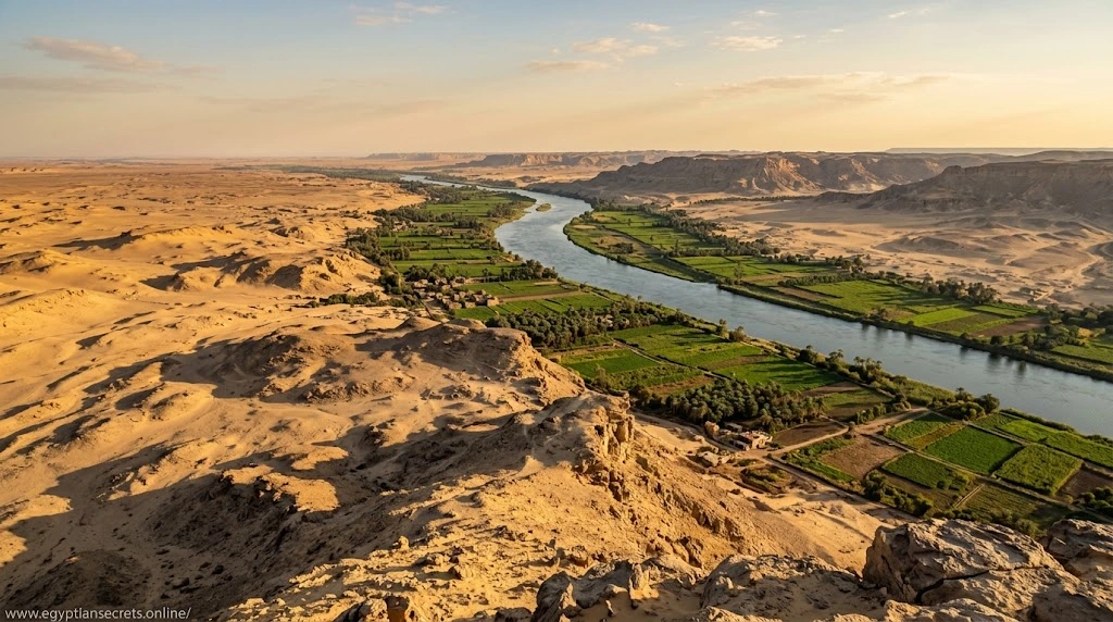
To the west is the Libyan Desert (part of the Sahara). To the east is the Eastern Desert (sometimes called the Arabian Desert). To the north is the Mediterranean Sea. To the south are cataracts and more desert.
This geography was both protective and isolating. The deserts made Egypt hard to invade. Armies moving through desert are slow, vulnerable, and struggle to find water. The Mediterranean to the north made Egypt hard to attack from the sea (at least in ancient times, before advanced naval warfare).
But the deserts also isolated Egypt. Compared to Mesopotamia (which was surrounded by more accessible neighboring regions), Egypt was geographically separated from its major neighbors. Egypt had trading relationships with the Levant (modern Syria/Lebanon area), with Nubia to the south, with Mesopotamia to the east. But these weren’t close neighbors. Deserts and sea separated them.
This isolation gave Egypt a certain independence and distinctiveness. Egyptian civilization developed somewhat separately from other Near Eastern civilizations. On a map, you can see why.
Egypt’s Neighbors: Geography and Ancient Trade Routes
On a complete ancient Egypt map showing neighboring regions, you’d see:
Nubia to the South: Modern Sudan. Nubia was resource-rich, and Egypt had ongoing trade relationships with Nubia. Nubia was also sometimes a conquest target for Egypt. On a map, Nubia appears as Upper Egypt’s immediate southern neighbor.
The Levant to the East: Modern Syria, Lebanon, Israel/Palestine. This was densely populated, with multiple city-states and kingdoms. Egypt traded with the Levant, fought with the Levant, and at various periods controlled parts of the Levant. On a map, it’s across the Sinai Peninsula from Egypt.
The Mediterranean: To the north. Sea trade was incredibly important for Egypt. Ships sailed north to the Levant and beyond. Island states like Crete had trade relationships with Egypt.
Mesopotamia Beyond: To the far east. Mesopotamia (modern Iraq) was another major civilization, but it was separated from Egypt by significant distance and difficult geography. Still, diplomatic and trade relationships existed.
On an ancient Egypt map with all these neighbors shown, you see Egypt positioned as a major power in the Northeast African and Eastern Mediterranean region, but geographically separated from other major powers by deserts and sea.
Ancient Egypt’s Boundaries Over Time
Here’s something important: the boundaries of ancient Egypt weren’t fixed. They changed over time.
At Egypt’s height (New Kingdom, roughly 1550-1070 BCE), Egypt controlled territory extending far beyond the Nile Valley. Under pharaohs like Thutmose III and Ramesses II, Egypt had conquered or controlled parts of Nubia to the south and the Levant to the east.
On a map showing the New Kingdom at its peak, you’d see Egypt’s territory extending significantly beyond what you’d see on an Old Kingdom map. This represents Egypt’s imperial expansion.
On a map showing Late Period Egypt (after around 1070 BCE), you’d see the territory contracting back to essentially the Nile Valley itself, as Egypt lost its imperial possessions and faced invasions from outside.
So “ancient Egypt on a map” is actually different depending on which period of ancient Egypt you’re looking at. The geography of the core Nile Valley stayed the same. But Egypt’s political boundaries expanded and contracted.
Reading an Ancient Egypt Map: Key Features to Look For
When you’re looking at an ancient Egypt map, here’s what to notice:
The Nile River: It dominates. It flows from south to north. All major cities are on or immediately near it.
Upper vs Lower Egypt: You can usually see the division marked on the map. Upper Egypt is the narrow strip in the south. Lower Egypt is the Delta in the north.
The Cataracts: The Nile has several cataracts (sets of rapids/waterfalls). These were natural barriers to navigation. The first cataract near Aswan marked the traditional southern border of Egypt proper.
Major Cities: Usually marked and labeled. Notice they’re all along the Nile.
Deserts: Surrounding the Nile Valley. These define Egypt’s geography.
Mediterranean and Red Sea: Bounding Egypt to the north and east.
Neighboring Regions: Sometimes shown for context—Nubia, Levant, Sinai Peninsula.
Why Geography Shaped Egyptian Civilization: The Big Picture
Understanding ancient Egypt on a map helps you understand why Egyptian civilization was what it was:
The Nile’s Predictability: Because the Nile flooded every year on a predictable schedule, ancient Egyptians could plan agriculture. This allowed population growth and civilization development.
Concentration: All Egyptians lived in the Nile Valley and Delta. This created a concentrated, unified culture (even though Upper and Lower Egypt had distinct identities).
Agricultural Surplus: The fertile Nile Valley produced more food than necessary for survival. This surplus allowed specialization—not everyone had to farm. Some could be artists, craftspeople, priests, scribes, soldiers. This is how complex civilization develops.
River Transport: The Nile was a highway. Moving goods, people, building materials—the Nile made it all much easier. On a map, you see the Nile as a natural transportation network running through the civilization.
Defensive Advantages: Surrounding deserts and sea provided natural protection. This meant Egypt could invest in culture and building rather than constant military defense.
Limited Expansion: The desert and sea also limited how much Egypt could expand. Egyptian power had definite geographical limits.
Geography isn’t destiny, exactly. But it shapes possibilities. The Nile shaped Egyptian civilization fundamentally.
Frequently Asked Questions (FAQ)
Q: Where exactly was ancient Egypt located?
A: Along the Nile River in northeastern Africa. Modern Egypt occupies roughly the same territory. Ancient Egypt was concentrated in the Nile Valley and Delta, surrounded by deserts.
Q: Why is it called Upper Egypt and Lower Egypt?
A: Upper Egypt is southern, called “upper” because it’s upriver. Lower Egypt is northern, called “lower” because it’s downriver. It’s confusing until you remember they named it relative to river flow, not geography.
Q: How large was ancient Egypt?
A: The core Nile Valley/Delta covered roughly 13,500 square miles of habitable land (the part near the Nile). But at its imperial height, Egypt controlled much larger territory including parts of Nubia and the Levant.
Q: Why was the Nile River so important?
A: It provided water in an otherwise desert region, created fertile soil through annual flooding, provided a transportation highway, and made agriculture possible. Without it, Egypt couldn’t exist.
Q: What was beyond ancient Egypt’s borders?
A: Desert to the east and west, the Mediterranean Sea to the north, and Nubia to the south. These natural boundaries made Egypt geographically distinct from other major civilizations.
Q: Did ancient Egyptians live in the desert?
A: Not really. They lived in the Nile Valley and Delta where water and fertile soil existed. The desert was used for mining and quarrying but not settlement.
Q: How did ancient Egypt’s geography compare to Mesopotamia?
A: Mesopotamia (between the Tigris and Euphrates rivers) was more open and accessible, surrounded by more neighbors. Egypt was more isolated geographically, surrounded by deserts and sea.
Q: What modern countries cover the area of ancient Egypt?
A: Primarily modern Egypt, plus southern parts of Sudan (ancient Nubia was part of Egyptian sphere).
Q: Can you visit ancient Egypt sites by looking at modern maps?
A: Yes! Many ancient sites still exist. Giza (pyramids), Luxor (ancient Thebes), Aswan, Cairo (ancient Memphis)—you can find them on modern maps in roughly the same locations.
Conclusion: Geography as the Foundation
Standing with an ancient Egypt map in front of you, the first thing that becomes clear is this: geography shaped everything. The Nile made Egypt possible. The deserts isolated it. The concentration of settlement along one river created a unified (if sometimes divided into regions) civilization.
When you understand ancient Egypt geographically—where it was, what surrounded it, why cities clustered where they did, how the Nile enabled everything—suddenly the entire civilization makes more sense. The trade networks, the political structure, the cultural focus, the achievements, the limitations—they all flow from geography.
That’s why understanding an ancient Egypt map isn’t just academic trivia. It’s understanding the foundation that made one of history’s greatest civilizations possible.
1 Comment